Landmarks and Mileage
A guide to features along the Delaware Canal
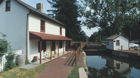
This Delaware Canal Landmark and Mileage chart shows the results of a comprehensive survey of the entire length of the Delaware Canal, in the interest of locating physical landmark features of the waterway such as locks, bridges, waste gates and the like. It is helpful for the user in that it indicates parking, picnic and restroom facilities, along with the landmark information.
The chart below is an abridged version of the most important landmarks along the Canal. For a full list of landmarks, which includes GPS coordinates, click here to view and download the PDF version of the Landmark and Mileage chart. In addition, for guidance on how to use the chart, click here watch a short video.
If you’d like to see the map for a specific location, simply open the PDF and paste the latitude (second column from the right) and longitude (right column) into a map locator such as Google maps, separating each set of coordinates with a space. Then click “Search Maps” to view the map.
For more information on this chart, you may download the author’s notes.
Landmark and Mileage Chart
| Miles from Bristol | What to See | Facilities | Canal Landmark, Structure or Feature |
| 0.14 | Lock | Tide Lock – Riverfront Park | |
| 0.29 | Lock | Lock 1 – Bristol Lock 1 | |
| 0.49 | Lock | Lock 2 – Bristol Lock 2 | |
| 0.55 | Lock | Lock 3 – Bristol Lock 3 | |
| 0.962 | Washington Street – Begininng of watered canal | ||
| 1.000 | Parking next to Grundy Mill, near RR Station at Prospect Street | ||
| 1.110 | Jefferson Avenue – Bristol Lagoon | ||
| 1.213 | Overflow from Lagoon, with foot bridge | ||
| 1.297 | Railroad Overpass (Amtrak) | ||
| 1.424 | Waste Gate | Adam's Hollow Waste Gate | |
| 1.47 | Stone culvert under Adams Hollow Creek | ||
| 2.119 | Green Lane | ||
| 2.706 | Lock | Lock 4 – Edgely Lock | |
| 3.085 | Edgely Road | ||
| 4.023 | Structure | Inverted Siphon Outlet at Levittown Shopping Center (Home Depot) | |
| 4.31 | Inverted Siphon Inlet at Levittown Shopping Center (Dunkin' Donuts) | ||
| 4.604 | Passageway under Southbound Route 13 | ||
| 4.667 | Passageway under Northbound Route 13 | ||
| 5.582 | Mill Creek Road, Falls Township Park 0.1 mile west | ||
| 5.692 | Waste Gate | Waste Gate | |
| 7.609 | Tyburn Road culvert, south end, trail detour | ||
| 7.713 | Tyburn Road culvert, north end, trail detour | ||
| 8.691 | Conrail Tracks over culvert, trail detour, the "Hill Climb" | ||
| 9.530 | Bridge Street, 7Eleven Shopping Center, trail detour | ||
| 10.179 | Waste Gate | Waste gate | |
| 10.320 | Trenton Avenue, leads to Calhoun Street Bridge | ||
| 10.706 | East Ferry Road | ||
| 12.261 | Black Rock Road over culvert | ||
| 13.25 | Path to Macclesfield Park | ||
| 13.281 | Yardley Water Co. 12" main | ||
| 13.340 | Lock | Lock 5 – Yardley Lock | |
| 13.486 | Letchworth Avenue – bridge | ||
| 13.59 | Silver Creek (earlier Van Horn Creek) | ||
| 13.751 | College Avenue – bridge | ||
| 13.977 | Afton Avenue (Route 332) bridge | ||
| 14.011 | Aqueduct | Yardley Aqueduct at Brock Creek, waste gate adjacent | |
| 14.376 | Mary Yardley Footbridge, Fuld Avenue | ||
| 14.693 | Camelback Bridge | Authentic Camelback Bridge, "Sommers" | |
| 14.871 | Lock | Lock 6 – Lear's Lock | |
| 15.093 | Structure | Spillway, concrete | |
| 15.117 | Interstate 95, Scudders Falls Bridge overhead | ||
| 15.15 | Structure | Overflow, natural | |
| 15.227 | Woodside Road, Park & Ride lot | ||
| 15.240 | Waste Gate | Waste gate | |
| 15.483 | Lock | Lock 7 – Borden's Lock | |
| 15.483 | Park Maintenance Area, Yardley | ||
| 15.947 | Waste Gate | Waste gate, overflow, Dyers Creek | |
| 16.097 | Mt. Eyre Road bridge | ||
| 16.348 | Bridge, queen post truss, "Milk House" | ||
| 16.50 | Milk House Creek | ||
| 16.686 | Camelback Bridge | Authentic Camelback Bridge, "Goat Farm" | |
| 17.002 | Aqueduct | Taylorsville Aqueduct, Hough's Creek | |
| 17.325 | Bridge, "Tebola Beans" of oil truck fame | ||
| 17.589 | Camelback bridge, "White's Bridge", only traces remain | ||
| 17.852 | Route 532, Washington Crossing, near Park parking area | ||
| 18.482 | Pedestrian bridge, "Crow's Bridge" | ||
| 18.756 | Remnants of Malone's Lower Bridge | ||
| 19.120 | Malone's Upper Bridge, "Buckstone", David Library | ||
| 19.37 | Old bridge abutment, only berm side now present | ||
| 19.60 | Old bridge abutment, only berm side now present | ||
| 20.041 | Aqueduct | Aqueduct – Lawless, Stoney Run, Jericho Creek | |
| 21.011 | Old bridge abutment | ||
| 21.459 | Bridge, concrete deck, Rossiter's | ||
| 21.789 | Stop Gate | Stop gate, Bowman's Hill (repaired 2008) | |
| 21.819 | Waste Gate | Waste gate, (Bowman's Hill, Pidcock Creek, Maintenance Area | |
| 22.000 | Revolutionary War memorial and grave site | ||
| 22.164 | Structure | Concrete overflow, Pidcock Creek (Neely's Creek?) | |
| 22.200 | Camelback Bridge | Authentic Camelback Bridge, "Thompson Neely" | |
| 22.266 | Culvert / bridge, Washington Crossing Park / Bowman's Hill | ||
| 23.045 | Ferman's Creek inlet | ||
| 23.573 | Flop Gate | Flop gate, controls river entry to canal | |
| 23.684 | Bridge, Water View | ||
| 23.742 | Bridge – Union Paper, The Waterworks entrance | ||
| 23.771 | Old stop gate, regulated flow into paper mill | ||
| 23.809 | Foot bridge to Waterworks | ||
| 23.82 | "Paper Mill Lock" removed 1847, wall segments remain | ||
| 23.840 | Bridge – Union Mills, The Waterworks exit | ||
| 23.990 | Bridge and inlet gate to Delaware, east of Canal | ||
| 24.001 | Bridge at Chez Odette, blocked to vehicles | ||
| 24.01 | Lock | Lock 8, drop gate upper end – New Hope Lock 8 | |
| 24.044 | Access / culvert to Chez Odette | ||
| 24.121 | Lock | Lock 9 – New Hope Lock 9 | |
| 24.14 | Waste Gate | Waste gate, Dark Hollow Creek | |
| 24.15 | Structure | Overflow | |
| 24.25 | Lock | Lock 10 – New Hope Lock 10, now area of Route 32 culvert | |
| 24.29 | Foot bridge at lower gate Lock 11 (2003) | ||
| 24.30 | Lock | Lock 11 – New Hope Lock 11, rebuilt 2003 | |
| 24.313 | Lock 11 – Locktender's House, Friends of the Delaware Canal | ||
| 24.53 | Aqueduct | Aqueduct New Hope, Aquetong Creek, Ingham Creek | |
| 25.409 | Rabbit Run Bridge, (Route 32 | ||
| 25.45 | Culvert, Rabbit Run | ||
| 25.65 | Route 202 Bridge overhead | ||
| 25.74 | Foot bridge, Malcolm Crooks, Solebury Canal Park (2009) | ||
| 26.136 | Phillips' Mill Bridge | ||
| 26.19 | Culvert, Primrose Creek (Phillip's Creek) | ||
| 26.799 | Lower Limeport Bridge, Hal H. Clark County Park | ||
| 27.213 | Upper Limeport Bridge, "Col. Haines" (replaced 2013) | ||
| 27.631 | Overflow, concrete (60' with railing) | ||
| 27.681 | Route 263, Centre Bridge-Stockton Bridge, Dilly's Corner | ||
| 28.024 | Redfield Bridge | ||
| 28.20 | Anchors for suspension bridge to Hendrick's Island, lost in 1955 flood | ||
| 28.56 | Johnson's Creek | ||
| 28.863 | Stop Gate | Stop gate, Virginia Forrest (repaired 2008) | |
| 28.880 | Waste Gate | Waste gate, Paxson Creek | |
| 28.967 | Virginia Forrest Recreation Area, new bridge (1998), river access | ||
| 29.48 | Structure | Overflow, concrete | |
| 29.912 | Private bridge, Delaware Quarries | ||
| 30.010 | Culvert under Canal, Cuttalossa Creek (replaced 2015) | ||
| 30.146 | Structure | Overflow | |
| 30.470 | Waste Gate | Waste gate and overflow, Lumberville Creek, Coppernose Creek | |
| 30.914 | Foot bridge, Lumberville to Bulls Island via Lock 12 & Route 32 | ||
| 31.018 | Lock | Lock 12 – Lumberville Lock | |
| 31.111 | Aqueduct | Aqueduct – Lumberville, Paunnacussing Creek | |
| 31.230 | Creek entrance | ||
| 31.285 | Structure | Overflow | |
| 31.425 | Raritan Dam, wing dam (D&R Canal feeder enters on NJ side) | ||
| 32.066 | Waste Gate | Waste gate and spillway | |
| 32.349 | Canal bridge at Lock 13, from Mountainside parking lot | ||
| 32.363 | Lock | Lock 13 – Point Pleasant Lock, White's Lock | |
| 32.45 | Point Pleasant Pumping Station | ||
| 32.524 | Lock | Lock 14 – White's Lock | |
| 32.547 | Waste Gate | Waste gate, Hickory Creek | |
| 32.712 | Vehicle bridge, Kinsman Company | ||
| 32.750 | Aqueduct | Aqueduct – Point Pleasant, Tohickon Creek | |
| 32.842 | Point Pleasant Avenue, Pratt Pony truss bridge (built 1877, rehab.1995) | ||
| 32.91 | Tohickon Creek | ||
| 33.386 | Smithtown Bridge No. 1, Walter's Nursery, "Clymers" | ||
| 33.945 | Smithtown Bridge No. 2, "Sollidays" (rebuilt 2003), Praul's Island access | ||
| 35.176 | Smithtown Bridge No. 3 | ||
| 35.19 | Lock 15 / 16 – Smithtown Locks, Locktender House present | ||
| 35.557 | Smithtown Bridge No. 4 | ||
| 35.574 | Waste Gates | Waste gates, Smithtown Creek, Worman's Creek on surveys | |
| 35.879 | Smithtown Bridge No. 5 (rebuilt 2013) | ||
| 36.189 | Lock | Lock 17 – Treasure Island Lock, bridge over Canal | |
| 36.814 | Structure | Concrete overflow spillway, waste gate | |
| 36.92 | Bridge, "Petritis", survey map notes "remains of abutment" | ||
| 37.195 | Aqueduct | Aqueduct – Tinicum Creek | |
| 37.361 | Waste gates | Waste gates | |
| 37.503 | Route 32 near Golden Pheasant Inn | ||
| 37.80 | Strructure | Overflow, masonry spillway | |
| 38.242 | Headquarters Road over culvert | ||
| 38.60 | Tinicum Park Picnic Area, road extension to Canal | ||
| 38.61 | Buckeye Co. Pipeline Crossing | ||
| 38.85 | Swamp Creek | ||
| 39.34 | Structure | Spillway | |
| 39.398 | Waste Gate | Waste gate, Ben Toy gate (earlier Farley's) | |
| 39.945 | Uhlerstown Hill Road covered bridge | ||
| 39.970 | Lock | Lock 18 – Uhlerstown Lock | |
| 41.311 | Camelback Bridge | Authentic Camelback Bridge, "Hazzard's" | |
| 41.756 | Lock | Lock 19 – Lodi Lock, DCSP Park Office, Lodi | |
| 41.84 | Waste Gate | Double waste gate | |
| 42.360 | Camelback Bridge | Authentic Camelback Bridge, "Spahr's" | |
| 42.701 | Berm Lane, bridge, "Gottlieb" | ||
| 44.887 | Vehicle bridge (and adjacent parking lot, Ringing Rocks Trail Access) | ||
| 45.03 | Falls Creek | ||
| 45.78 | Stop Gate | Stop gate, Indian Rock | |
| 45.838 | Waste Gate | Waste gate, Narrowsville | |
| 45.86 | Indian Rock Inn | ||
| 46.730 | Lock | Lock 20 – Narrowsville Lock, Parking Bridge | |
| 47.162 | Aqueduct | Gallow's Run Aqueduct | |
| 47.708 | Island Road, Evans Bridge | ||
| 47.878 | Nicholas Bridge | ||
| 48.244 | Trauger's Bridge – Farm Market | ||
| 48.573 | Stop Gate | Stop gate – Trauger's | |
| 48.603 | Trauger's Bridge | ||
| 48.700 | Structure | Overflow, spillway | |
| 48.71 | Masonry arch – Rodges Run | ||
| 49.227 | Lock | Lock 21 – Durham Lock | |
| 49.267 | Aqueduct | Aqueduct – Durham, Cooks Creek, Durham Creek | |
| 49.403 | PA Fishing & Boating access, large wooden vehicle bridge | ||
| 50.28 | Foot bridge (new 2009) to Riegelsville Roebling Bridge | ||
| 50.340 | Delaware Road – Riegelsville Bridge | ||
| 51.327 | Foot bridge to Mueller's Kitchen and General Store | ||
| 51.327 | Stop Gate | Stop gate, Rocky Falls | |
| 51.356 | Waste Gate | Waste gate, Rocky Falls | |
| 52.136 | Aqueduct | Aqueduct – Kleinhan's, footbridge, Frys Run, Kleinhan's Creek | |
| 53.104 | Theodore Roosevelt Recreation Area (canoe access) | ||
| 53.104 | Canal Road Bridge – Access to Recreation Area | ||
| 53.11 | Lock | Locks 22 / 23 – Groundhog Lock, Raubsville Lock | |
| 53.425 | Foot bridge | ||
| 53.948 | Structure | Emergency overflow with wooden foot bridge | |
| 54.076 | Structure | Overflow | |
| 54.171 | Camelback Bridge | Authentic Camelback Bridge, "Smith's," aka "Woody's" | |
| 54.728 | Waste Gate | Waste gate, foot bridge, waste gate, near Brown's Terrace | |
| 56.20 | Wooden foot bridge to Wy-Hit-Tuk Park – "Monet" Bridge | ||
| 56.570 | Stop Gate | Stop gate, Wy-Hit-Tuk, vehicle bridge | |
| 57.297 | Waste Gate | Waste gate – Black Iron Frame | |
| 58.002 | Stop Gate | Foot bridge, stop gate, Easton Treatment Plant | |
| 58.03 | Flop Gate | Flop gate to Delaware River | |
| 58.88 | Lock | Lock 24 – Easton Lock, Guard Lock | |
| 58.899 | Guard Lock / Forks of the Delaware / Fish Ladder |